HomeApplicationsProductsTechnologyCode-LessAboutResourcesRequest a Demo
Physical AI Platform

Perceive. Decide. Act. Learn.

Physical AI in execution — navigation, safety, fleet, and telemetry engineered as one loop, behind every application on your floor.

The Loop

One stack. Four questions.

A mobile robot answers four questions thousands of times a shift: Where am I? (navigation) Is it safe to move? (safety) What should I do next? (Fleet Manager) How is it working? (telemetry and Code-Less). Each answer feeds the next. We built one stack across all eight models, so when the loop improves, every robot improves.

Read the Physical AI explainer

01

Perceive · Navigation

LiDAR builds a real-time map while tracking position. No floor markers, no magnetic tape, no construction. DM Code tags at docking provide ±10 mm precision.

02

Decide · Safety

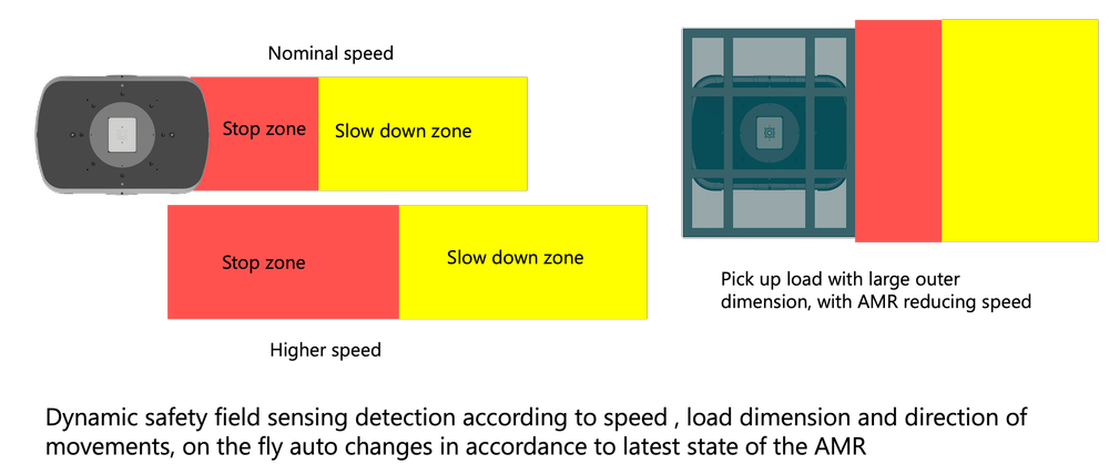
UL 3100 + EN 3691-4 certified by SGS. Dual safety-rated LiDAR with 510° combined field of view. Dynamic fields adapt to speed, load, and direction.

03

Act · Fleet Manager

Up to 50 AMRs, single interface. Real-time monitoring, task scheduling, dynamic routing. WMS/ERP via REST API. No per-robot SaaS fees.

04

Learn · Telemetry

Every task, route, dwell, and intervention recorded. Code-Less turns the data into workflow changes — no developer, no downtime.

Perceive · Layer 01

SLAM + Tag Hybrid Navigation

The AMR uses LiDAR to build a map of its environment while simultaneously tracking its position — Simultaneous Localization and Mapping. Walls, pillars, and racking become natural reference points. No floor markers. No magnetic tape. No construction.

At transfer points, DM Code tags provide ±10 mm precision and ±1° angular accuracy. The bottom-facing Smart Vision Camera reads them automatically. The loop closes exactly where precision is required — and only where it is required.

The trade-off. LiDAR costs more than QR-code hardware. It eliminates facility modification, which typically runs 30–50% of project cost. For a facility that changes layout every 12 months, the savings compound with every reconfiguration.
SLAM navigation
Decide · Layer 02

UL 3100 + EN 3691-4 Certified Safety

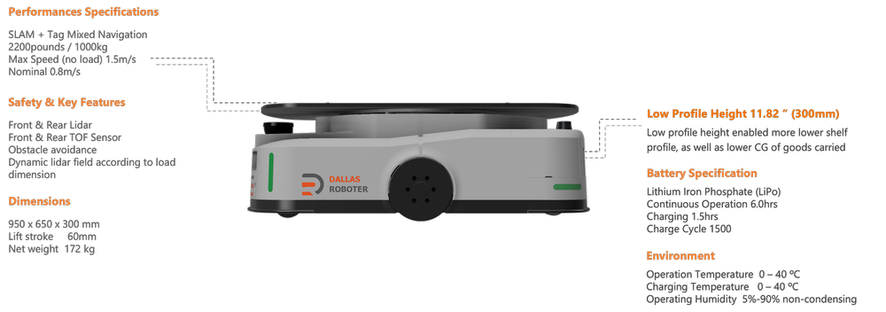
A robot carrying 1,000 kg at 1.5 m/s carries real kinetic energy. At 1.5 m/s with a 100 ms reaction time, it travels 150 mm before braking even begins. Safety is a constraint on every decision, not a feature bolted on at the end.

Independently certified by SGS. Standard on every model. Dual safety-rated LiDAR with 510° combined coverage, dual Time-of-Flight sensors for the vertical blind spots, and dynamic safety fields that widen with speed and load and tighten for precision maneuvering.

Safety LiDAR
Act · Layer 03

Fleet Manager Software

One AMR is a tool. Ten are a transportation network. Fleet Manager schedules tasks by priority, availability, and route efficiency — and re-routes around a blocked aisle instead of waiting for it to clear.

Up to 50 AMRs from a single interface. WMS/ERP integration via REST API. Opportunity charging coordinates energy across the fleet: 8 hours rated operation, 1.5–2 hours to full charge, no dedicated charging downtime. Included — no per-robot SaaS fees.

Fleet Manager
Learn · Layer 04

Telemetry + Code-Less

The loop only improves if it closes. Every task, route, dwell time, and intervention is recorded — and the data answers questions an operator actually has: where does the aisle congest at shift change, which transfer point needs a tag moved, which loop is close to capacity.

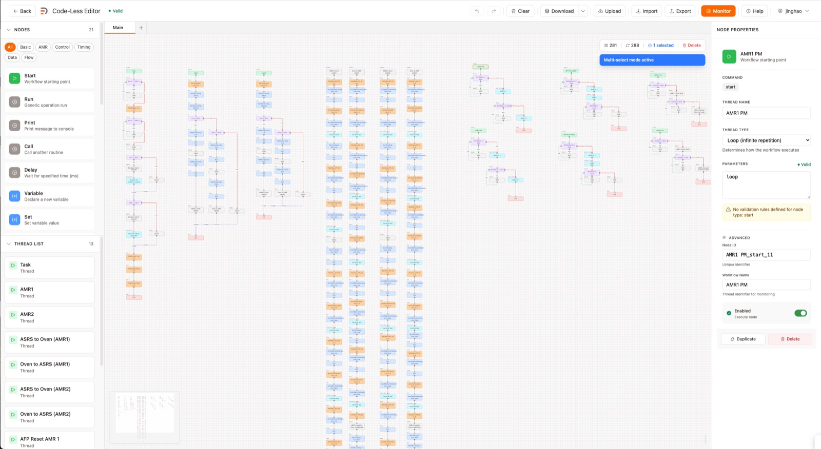
Code-Less turns those answers into changes. A node-based canvas lets the person who understands the process edit the process — drag, connect, configure. A route changes in minutes, not days. No developer queue, no vendor call, no downtime.

See the Code-Less Platform

Code-Less workflow editor
Technology Comparison

SLAM vs legacy navigation.

MethodInfrastructureDeploymentFlexibilityMaintenance
SLAM + Tag (DR)None2–4 weeksAny path, dynamicLow
QR CodeCodes in floor2–6 weeksFixed pathsMedium
Magnetic TapeTape throughout4–8 weeksFixed pathsHigh
Laser ReflectorsReflectors on walls3–6 weeksLine of sight onlyMedium
The Last 10%

Where the loop meets your building.

Simulation gets you 90% of the way. The building is the last 10%: the pallet that sits 40 mm off centre, the aisle where a stretch-wrapper blocks the scan, the dock that floods with sunlight at 4 p.m. We map those edge cases during deployment, because they only appear on your floor, on your shifts, with your people. That is the difference between a demo and a deployment.

±10 mm position accuracy. ±1° angular accuracy. At all rated loads. For all models. No floor markers.

Dallas Roboter Platform · Validated by SGS · 24/7 US-Based Support

See the loop run.

Request a live demo or a technical deep-dive with our engineering team.